![]()


This walk: 2007-10-29 - Scout Hut car park - track towards Eylebarrow - Plym Steps - previously unseen "Cist-8" and Cists-11 & 12 - Plym Steps blowing house - double mortar stone - ponies - other ruins. This walk was planned to see cists that were not seen on a previous walk.
Walk details below - Information about the route etc.

Isolated rock at SX 61014 66720 � 5 m that appears a little "cairn-like", a few meters uphill from .....

Cist-7 at SX 60983 66714 � 5 m (GPS 'fix') that appears on the walk from the first attempt to locate these cists, here. Photographed looking down Langcombe Brook towards the Plym valley with Sheepstor at top left.
Previously, on that page, this was GPS-fixed at SX 60983 66715 - not bad, eh, Dave?
Then came the search for the missing "Cist-8" from the first walk .....

The previously unfound "Cist-8" at SX 60950 66737 � 5 m, in the right foreground. No wonder it was hard to find, approximately 46-50 m from the other cist but almost below ground level in tall grass. This is a large, very fine oblong stone box, with no cover stone, 319-320� magnetic from the original, easy-to-spot cist. The height of the grass can be judged from the appearance of the rucksack (fairly large, 50 L).

Cist-11 at SX 60375 66921 � 4 m GPS-fix, looking towards Plym Steps with Langcombe Brook on the right

Cist-12 at SX 60426 67112 � 5 m (GPS-fix), the tilted cap stone is easily seen from the path used, just 190-200 m from the river crossing

.... and a closer view of the same cist

A view along a possible leat bed above the blowing house that is close to Plym Steps. The ruins of the house are in the centre of the picture with the River Plym on the right

Looking up the Plym valley with the blowing house ruins in the foreground and Lower Hartor Tor at top left. Note the 'mound' at near left because the double mortar stone is leaning against its left face, out of sight here. The GPS-fix here in the middle of the ruins was SX 60352 67237 � 4 m.

Looking at the blowing house from above, on the possible leat

Mortar stone with two depressions - hopefully the stereo image of this will be more defining. Aha - the stereo image really shows this stone in 3D and illustrates the value of this technique!

Looking eastwards, up the Plym, from beside the blowing house

Ponies at Plym Steps

Feature at SX 59200 67698 that resembles a cairn(?) but inside a 'modern' enclosure

Same area as previous photo but looking down the Plym valley, note the long object at the right (in later photos) - I am now told it is a flue from the mine workings

Similar to previous, with the Plym behind and Shavercombe Tor near the skyline, right

Unusual long 'barrow-like' construction, almost like a leat covered with flat stones ..... actually, I am told this is a flue from the mine workings

..... and again

Another view of the nearby ruins

Looking back, south-eastwards from a wall corner (at left) of these ruins
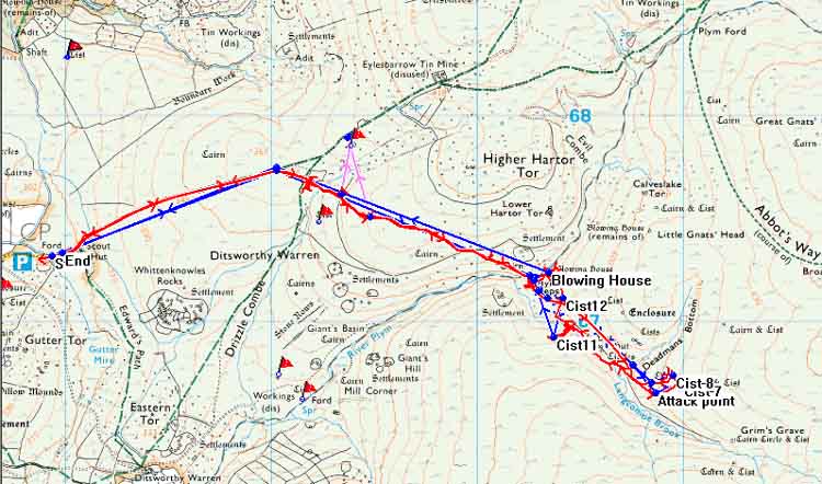
MAP: Blue = planned route, Red = GPS track of the actual walk
Reproduced from Dartmoor OS Explorer map 1:25 000 scale by
permission of Ordnance Survey
on behalf of The Controller of Her Majesty's
Stationery Office.
© Crown copyright. All rights reserved. Licence number 100047373.
Also, Copyright © 2005, Memory-Map Europe, with permission
Map above showing the entire walk. The blue, planned route was for compass planning, the red GPS-recorded track was mostly on tracks and paths, except for the approaches to the cists. The two pink lines are for someone at Compassworks to admire! See 3rd map, below.

Reproduced from Dartmoor OS Explorer map 1:25 000 scale by
permission of Ordnance Survey
on behalf of The Controller of Her Majesty's
Stationery Office.
© Crown copyright. All rights reserved. Licence number 100047373.
Also, Copyright © 2005, Memory-Map Europe, with permission
Map above showing detail of the cist travels. Other indicated cists were visited previously, here

Reproduced from Dartmoor OS Explorer map 1:25 000 scale by
permission of Ordnance Survey
on behalf of The Controller of Her Majesty's
Stationery Office.
© Crown copyright. All rights reserved. Licence number 100047373.
Also, Copyright © 2005, Memory-Map Europe, with permission
An interesting, apparently almost complete small ruined, building presented itself during the walk. It was 'located' by two diversions from the 'main' (and unmapped) path, by walking directly towards it for 30-50 meters so that the red GPS tracks would indicate its direction from those two points. By extending these short red tracks, the pink lines added to the map indicate its approximate position. Obviously, it is near the main bridleway to Eylesbarrow mine but I don't remember it from walks done 1979-1984, but that says only something about my memory!
Just for fun, the position drawn above is SX 59385 67853. I will try and visit the structure properly and get a real GPS fix to compare. (See 22 November for more details)
The roads via Yelverton, Dousland, Burrator dam and Sheepstor village are good, but they narrow markedly before the village.
Parking was at the P symbol on the map at SX 57880 67300, near the Scout Hut.
Statistics
Distance - 9.07 km / 5.64 miles
Start 10.30 am, Finish 2.28 pm, Duration 3 hr 58 min
Moving average 3.7 kph / 2.3 mph; Overall average 2.2 kph / 1.4 mph
All photographs on this web site are copyright ©2007-2016 Keith Ryan.