

This walk: 2007-11-22 - Scout Hut - Eylesbarrow - tin mine - workings - unidentified object from a previous walk (which is noted below) - cist
Walk details below - Information about the route etc.

Boundary stone beside the track marked "BWW 1917" (Burrator Water Works 1917), indicating the edge of the catchment area for Burrator Reservoir

This is the "small building" noted on a walk on 29 October 2007, that I marked on the track by recording two diversions towards the object on the GPS track. On that occasion, I had cut short a long-ish walk looking at cists and did not feel like walking across country to see what this was. I noted "Just for fun, the position drawn above is SX 59385 67853".
In reality, it was 'GPS-fixed' today as being at SX 59395 67869 � 4m. This is only 10 m out in one direction (east-west) and 16 m out in the other (north-south) � 4 meters. Not bad for remote 'fixing' by deviations in the GPS track from the previous walk?

Another view, with Sheeps Tor (369 m / 1210 ft) to the right, behind

Another view, with Sharpitor (405 m / 1328 ft, on the skyline) and Leather Tor (376 m / 1233 ft) behind

Closer view showing a fern (Polypodium vulgare) cloaking the top section of the wall

Final view, showing the possible 'run' of a dried up leat running into the distance

Eylesbarrow tin mine (disused) at about SX 59800 68180

Fenced-off pit/shaft, further on, past the old buildings

Rain sets in at the top of Eylesbarrow (454 m / 1489 ft). View from first cairn to second cairn. There is a trig. point (triangulation pillar) between them.

Part of one of the cairns on the top of Eylesbarrow (454 m / 1849 ft)

Another pit

View along the track towards Nun's Cross and Whiteworks

More pits along the track above the disused buildings

Looking up the valley of Langcombe Brook

Looking back down towards the Scout Hut, showing the double row of stone supports that were used to transmit power further down/up the track

Closer view, the stones are notched on the top flat surface

Cist at SX 59229 67482

View of the cist looking towards north towards other ruined buildings seen on 29 October 2007

A closer view of the cist

The cist with Hen Tor behind at 2.1 km / 1.3 miles
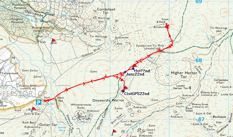
Red = GPS track of the actual walk. Just for once, there was no blue pre-programmed GPS route for this short walk up a track and back with just a couple of detours off to the side.

Reproduced from Dartmoor OS Explorer map 1:25 000 scale by
permission of Ordnance Survey
on behalf of The Controller of Her Majesty's
Stationery Office.
© Crown copyright. All rights reserved. Licence number 100047373.
Also, Copyright © 2005, Memory-Map Europe, with permission
Access was via Plympton towards Burrator Reservoir, along a road that passes over Cadover Bridge. After Ringmoor Cottage it becomes single track, high up overlooking Sheepstor village. Not my favourite spot on a wet or icy day because the only passing possibility along one stretch is to go on the grass on a steep downward slope away from from the road! I would favour the safer approach via Yelverton, Dousland and Burator dam. Parking was at the the P symbol on the map.
Statistics
Distance - 7.01 km / 4.4 miles
Duration 3 hr 5 min
Moving average 3.8 kph / 2.4 mph; Overall average 2.3 kph / 1.4 mph
All photographs on this web site are copyright ©2007-2016 Keith Ryan.