![]()


Cists galore!
This page describes a bit of a marathon walk for me - visiting cists (on the Ordnance Survey map) otherwise known as kistvaens*
"Kistvaen - A stone coffin, from from the Celtic cist, a chest, and maen, stone, v being used as a mutation of m. (Source: Crossing's Guide to Dartmoor, 2nd edition 1912, reprinted 1990, page 22)."
The walk involved some rough ground - probably the last such this year for me involving this sort of ground - the grass was in tussocks reaching above the knee. There were some run-off channels hidden between the tussocks that reached more than a foot in depth, ample opportunity for injury to the unwary!
Walk details below - Information about the route etc.
This walk: 2007-9-18 Whiteworks - Nun's Cross - Nun's Cross Farm - Nun's Cross Ford aka Plym Ford - Great Gnats Head - Cist-1 (possibly miss-marked on the map or possibly with a second cist close-by that is not on the map) - Calveslake Tor - Cist-2 - Cist-3 - Cist-4 (Grim's Grave) - Cists 5, 6, 7, (8), 9 & 10 (all situated in or along the Langcombe Brook that runs down to Plym Steps) - Plym Steps - Lower Hartor Tor - Higher Hartor Tor - Eylesbarrow Tin mine - back to Whiteworks. Not all the non-cist features were photographed and they will be covered in another walk. The cist locations can be seen on the map at the bottom of the page, and GPS positions 'fixed' on the day are given for each one.
Cist-8 could not be found. Cists-11 & 12 were missed out because they involved crossing a valley (twice) and the legs had just about had enough by that time!

Nun's Cross also known as Siward's Cross at SX 60477 69950 (GPS 'fix' � 4 m on the day), close to Nun's Cross Farm (not as on the map at SX 60165 69918 - I must check that feature sometime?). The feature was investigated here (27 Sep 2007) and there are also more details about the cross - photographed from the other direction.

Sign above the door at Nun's Cross Farm

Nun's Cross Farm (SX 60583 69835)

Nearby cross at SX 61313 69500, visited as an interesting detour. A cross is engraved into the stone

As previous photo - the "cross" actually looks like a standing stone

Nun's Cross Ford aka Plym Ford (SX 6104068408)

Cist-1 at SX 61199 68030 (GPS position 'fixed' on the day) - possibly it is the cist mapped at SX 61205 68045, but see below

Extra Cist-1, at SX 61173 68035 (GPS 'fix'). This was located half-way between the track (which I couldn't see) and the previous photo which was about 115 m from the 'track'. This was stumbled across in direct line from the attack point on the notional track! I was impressed at this bit of map, compass, timing and 'pacing' work, but surprised when I found it short of the real goal point! There seem to be two structures at this location. Thank you for the Navigator Level 2 course, Compassworks!

En route to Calveslake Tor (SX 60820 67628)

As previous photo, but some meters closer

Cist-2 (SX 60874 67551 - GPS 'fix')

Cist-3 (SX 61201 66982 - GPS 'fix')

Cist-4, Grim's Grave cairn circle and cist, at SX 61245 66422 (GPS 'fix')

As previous, Grim's Grave

Another view of Grim's Grave, as previous two photos

Cist-5 at SX 61250 66310 (GPS 'fix'). This cist seems well covered by the cap stone

Cist-6 at SX 60865 66153 (GPS 'fix')

Cist-7 at SX 60983 66715 (GPS 'fix')
Cist-8 could not be located - the area was one of long tussock grass - it will be revisited at a later date

Cists-9 & 10. Cist-9 is in the foreground beyond the large flat stone (back and right), cist-10 is seen in the background with the tilted capstone (centre of photo)

Cist-9 at SX 60787 66893 (GPS 'fix)

Cist-10 at SX 60781 66900 (GPS 'fix')

Looking back at cist-10 (nearest) and cist-9 (beyond, back and right)

Lower Hartor Tor (SX 60360 67530)

Plym Steps (SX 60245 67193) - the type of grass and rush encountered in the area are shown well here and make for difficult walking when densely packed

Higher Hartor Tor (SX 59968 67748)

The 'motorway' path from Eylesbarrow tin mine to Whiteworks!

From SX 60400 69380 directly along the "wall" that
runs across the landscape on the map
(Angela - a bit like "Irishman's Wall" near Belstone - Hadrian never came this
way!)

View from the return path to Nun's Cross Farm (centre of photo)
The road from Princetown to Whiteworks is a long single carriageway road with passing places. I only met one tractor! There are two parking areas just short of the P symbol on the map where four or five cars can park in each. The area on the map marked as P is a little larger.
MAP: Blue = planned route, Red = GPS track of the actual walk

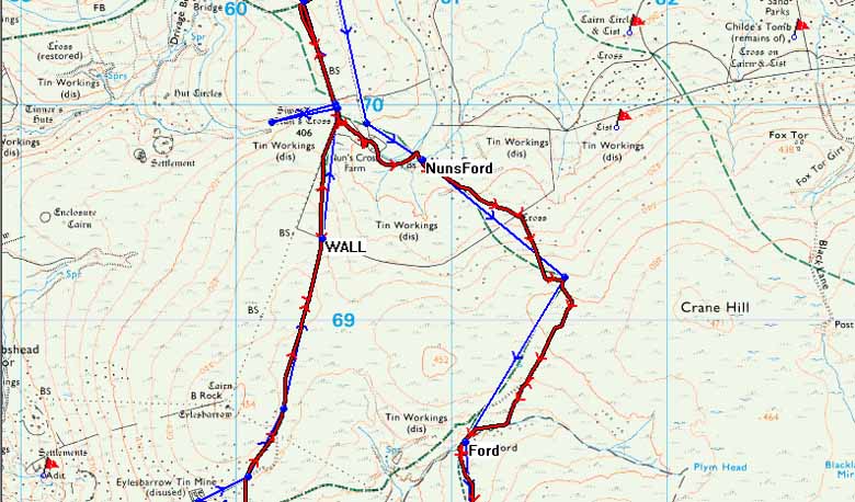

The route and recorded track are shown as three images because the www.dartmoorcam.co.uk Ordnance Survey license terms stipulate that images larger than 800 x 600 pixels cannot be shown
The 'track' (the red GPS record of the walk) deviates from the blue planned route on occasion when animal tracks or other paths were followed to make walking easier
The red flag markers indicate other cists that it is hoped to visit at later dates. The non-OS names are from the route plotted on Memory Map and downloaded to the GPS as a safety back-up to the map and compass exercise that was the basis of this walk. Some cists are located in featureless locations and finding them by map and compass alone would be difficult. GPS was used twice to locate the final position and even with GPS, one cist (Cist-8) was abandoned as being invisible in long tussock grass. Possibly, as with Cist-1, it is not placed on the map at the correct position?
One cist (Cist-3) was located after a 100-meter 'boxing' exercise around a boggy area. This is recorded on the GPS track (the red trace) - one of the techniques taught on the Compassworks Navigator Level 2 map and compass course (thank you, Dave!).
I then disgraced myself en route to Cist-4 by not setting the next compass bearing (shown on the red track record) and had to use GPS to fix my position!
It was just before Cist-6 that the dangerous (i.e. deep, hidden) rainwater run-off channel was found: in fact, this must have been the stream marked on the map.
Statistics: distance 14.4 km/8.9 miles; moving average 3.4 kph/2.1 mph; overall average 1.9 kph/1.2 mph; time 7 h 5 min. In places, progress was slow because it was necessary to 'feel' with the foot before placing it down.
All photographs on this web site are copyright ©2007-2016 Keith Ryan.