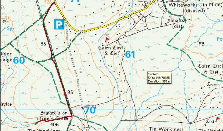


This stroll was to investigate the structure marked on the map at SX 60165 69915 beside Nun's Cross, aka Siward's Cross, as noted in the previous walk .....

Reproduced from Dartmoor OS Explorer map 1:25 000 scale by permission
of Ordnance Survey
on behalf of The Controller of Her Majesty's Stationery Office.
© Crown copyright. All rights reserved. Licence number 100047373.
Also, Copyright © 2005, Memory-Map Europe, with permission
Walk details below - Information about the route etc.
This walk: 2007-9-27 - Whiteworks - Nun's Cross - tin ruins - boundary posts

This is the scene at SX 60165 69915, an abandoned miners hut. There are extensive diggings from here towards Nun's Cross

A view of the hut

Another view

View showing the steep-fronted Sheepstor (left, at 3.98 km, 2.5 miles), Devonport Leat emerging from the Nun's Cross underground section, with Down Tor and Burrator forest (Raddick Plantation) behind, and Leather Tor and Sharpitor (rightmost, behind)

Closer view of Devonport Leat - sorry, Prince's Trust guys - I saw no boats!

View back towards the leat tunnel

Zoomed view of Sheeps Tor (at SX 56587 68265)

Nun's Cross with the sun on it, revealing what was invisible an hour earlier in the shade

Inscription on the face towards the west: interpreted previously as Roolande, Bod Bond and Booford. Settled by Crossing's 1884 book on Dartmoor's crosses as saying 'BOC LOND', being the ancient form of 'Buckland'. (Source: Crossing's Guide to Dartmoor, 2nd edition 1912, reprinted 1990, page 104)

The large path running roughly north/south, Princetown/Whiteworks and further south and west to Eylesbarrow and eventually to the Scout hut and Sheepstor village

Boundary stone on the path, marking the limit of the catchment area of Burrator Reservoir: PCWW 1917 (Plymouth Corporation Water Works) - see HERE for details. The inscription cannot be seen from the path, it is on the rear face of the stones
Much as the previous walk for access etc: the road from Princetown to Whiteworks is a long single carriageway road with passing places. There are two parking areas just short of the P symbol on the map where four or five cars can park in each. The area on the map marked as P is a little larger.
MAP:
Red = GPS track of the actual walk - this was only recorded for the return leg. The walk was very simple, being on major paths and only 3.98 km/2.47 miles.

All photographs on this web site are copyright ©2007-2016 Keith Ryan.