

This walk: 2011-3-2. Blackaton / Roman's Cross, Trowlesworthy Tor, Sheep's Tor, gert, single stone row, rabbit warren, rabbit bury, pillow mound, hut circle, sheep bridge, The Pulpit stone circle, double stone row, china clay pits, Spanish Lake, Shell Top, Penn Beacon, possible mudstone, breccia, pony jaw bones, Hanging Stone, frog spawn, granite constituents.
Walk details below - Information about the route etc.
Some extra photos taken on the following day, 3rd March.
The Moor Strollers gathered at Blackaton Cross. Dartmoor Crosses web site says: Although generally known as Blackaton Cross, it is sometimes referred to as Roman�s Cross. The reason for this alternative name is not known for sure, but there may be a connection with the monks of Tavistock Abbey. St Rumon is one of the saints to whom the Tavistock Abbey is dedicated and it could have been named by these monks on their passage across the moor. William Crossing prefers the alternative suggestion that it was so named as a shortened version of the �Roman Catholic Cross�, again in association with the monks passing this way across the moor. The name Blackton is taken from the nearby Blackaton Slaggets, an area that was once extensively used for cutting peat.
The cross was re-erected prior to 1937 by Mr Philips of Lee Moor House, using a window sill as the shaft. The socket and head are original with the socket being a boulder, roughly circular. The cross was a wayside cross, marking a turn-off point on the Cornwood-Tavistock track on to the track to Shaugh and Plympton.
Looking under the head of the cross where it joins the shaft - one can see daylight!
The lonesome pine, found at last?
Greater Trowlesworthy Tor, SX 579 643, elevation 357 metres (1171 feet). A double stone row can be seen at lower left running up to left edge of the photo, half way down.
Zoomed view to Sheep's Tor, SX SX 565 682, elevation 369 metres (1210 feet).
Gert at SX 5737 6343, the odd aspect here is that there is no sign of any spoil heap in the area .....
Another branch of the diggings ..... a very large hole in the ground!
A view of the peat layer.
Trowlesworthy Tor again.
The un-straightest stone row on Dartmoor?
Suzi successfully crossing something deep and wet!
Zoomed view to Trowlesworthy Warren House (a farm).
One end of a rabbit bury, marked on maps as "pillow mounds" - Trowlesworthy Warren was a large rabbit warren, providing meat when the area was actively worked by the miners ....

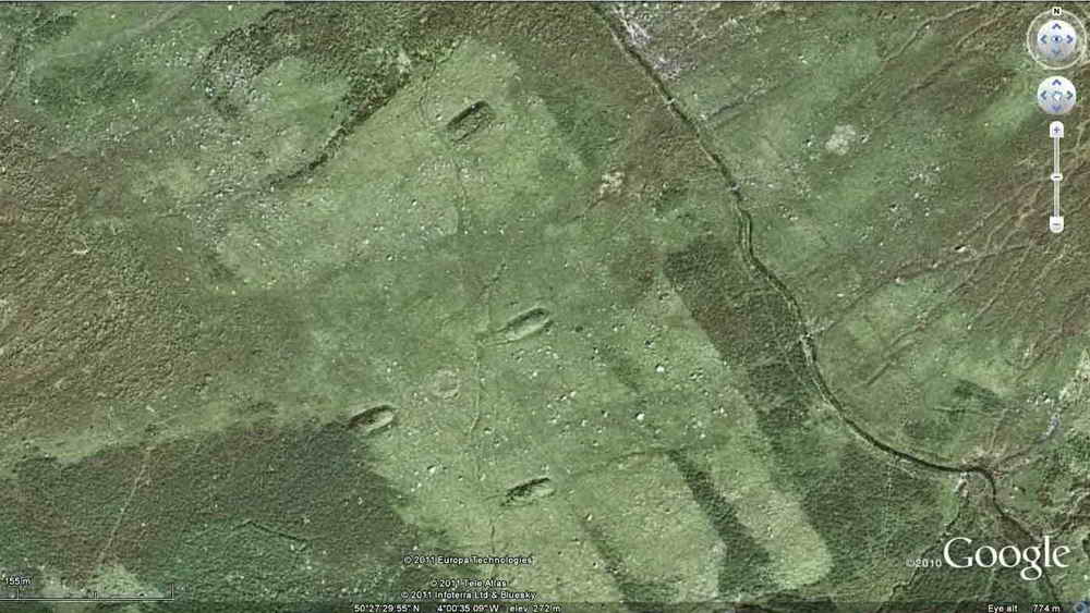
Google Earth view of this area - the pillow mound pictured is one of these ..... believed to be the middle one .....
The same mound seen end-on. The buries were made of dry soil with a drainage ditch around them sometimes, otherwise rabbits would not live in this area. There were vermin traps around against stoats and weasels. The rabbits were caught in nets placed over the holes.
A nearby hut circle - the area is rich in remains (see the map below).
Another pillow mound with a stone row behind .....
A view of the row ......
The large blocking stone on the end is normally has its width across the axis of the row but this does not, re-erected at some time?
Crossing a sheep bridge, one of several put across the Lee Moor Leat, formerly the Bottle Hill Mine Leat. The bridges were provided so that rabbits could cross the leat without getting their feet wet, because they don't like it!
A sheep that would NOT cross the bridge, even though the rest of the group did. It walked off along the other side of the leat to the others.
The Pulpit ....... a circle on the end of a double stone row .....
One stone in the circle has a peculiar weathered shape .....
Double stone row - note the lonesome pine against the sky in the distance.
Trowlesworthy Tor.
A big hole in the ground - a china clay pit.
Trowlesworthy Tor again.
Zoomed view to the north, to Shaugh Lake China Clay Works.
Looking across to Spanish Lake - so named after the occupants of Trowlesworthy rushed up here to bury their money and valuables after the Spanish Armada was sighted.
Somewhere here is Hexton Tor, SX 582 637, but there is no photograph of it.
View to the distant tops of Shell Top (left) and Penn Beacon (right).
Pixies' snot? Possibly produced by a female frog whose egg-laying process has gone awry.
Spanish Lake - "lake" meaning a stream on Dartmoor .....
Low-angle view from inside the eroded-down stream .....
The bed of the stream is made of a brown sedimentary rock, possibly a mudstone, or shale but .....
The rock also contains inclusions of other small pieces of rock, a breccia?
Jim in Spanish Harlem ............. sorry, Spanish Lake.
Resting point.
Lower jaw bones of a pony.
The Hanging Stone, this link tells the story of the sheep stealer who accidentally hanged himself while fleeing from a horseman with a butchered sheep tied around himself - in his flight the a rope caught around the stone as he ran by, either breaking his neck or hanging him .....
Examining the inscription on the stone .....
The Legendary Dartmoor web site states: that the stone is a menhir which dates back to the Bronze Age. Butler (1994, p. 162) has the following to say about the menhir:
"... a massive leaning slab 2.2 m high and 1.2 m across at the base with the letters BC cut into the east face. Though appropriated as a boundary marker, the stone is much larger than the usual posts put up for similar purposes elsewhere on the moor, including the neighbouring one in a series, and may well have been erected as a standing stone in prehistoric times".
Some have suggested that the bounds which the stone marked were that of Cholwich Town hence the BC. However, Brewer (2002, p.235) refutes this and argues the letters are more likely to denote the limits of the original China clay sett, 'C' representing - clay. The menhir is also sometimes known as the 'Leaning Rock' for reasons that are obvious when viewed from a certain angle, this is one of several such named stones on the moor, with at least one having the same legend attached to it.
Do you see "BC" - and where is it?
Click on the photo to see a larger version of the panorama from this spot - the Hanging Stone is just seen at the left edge.
Frog spawn.
The track back towards the car park, going towards Big Pond.
| Dartmoor CAM movie Moor Strollers view if the Whitehill Yeo China Clay Works in particular, with views into neighbouring Cholwich and Lee Moor China Clay Works. The full north-west to south-east extent of the workings is 3.2 km (2.0 miles) - a big hole in the ground.
|
Click the photo to download the movie |
China clay - Lee Moor land was leased by the Earl of Morley in 1830 to William Philips and the venture was very successful by the early 1900's. For every ton of clay there is 10 tons of waste. There is increasing demand, the coarse sand (mica and quartz) also known as silica sand, is used in building (cement, concrete, compound and filler). Clay production is energy intensive, involving washing, separating, blending, pressing and drying. 100 years of reserves are remaining. The clay leaves Lee Moor as a thick slurry in a pipe running five miles to a drying plant at Marsh mills. 50% of the clay is used in paper-making, also used in ceramics, paints, cosmetics, plastics, pharmaceuticals, food additives, anti-diarrhoea medicine, ice cream and toothpaste. Kaolin - Chinese for "white hill". 6,000 tons produced annually.
Crossing a stream.
Marker stone along the track where several, like this one, are breaking down into gravel or "growan" .....
Close-up of the broken down granite - not quite china clay yet!
Kaolin is essentially "rotted" granite where the feldspar crystals have decomposed.
Modified from: PZNOW - Penwith's Tors web page, now unavailable .....
|
The composition of granite gives it a distinctive appearance. The proportion of the minerals that make up the granite varies from location to location. The main constituents of granite are, feldspar, quartz, biotite and muscovite. Also commonly found are pieces of other rock that fell into the granite before it cooled. These are xenoliths. |
|
Orthoclase (feldspar, colourless) |
KAlSi3O8 |
Good examples of these crystals can seen in some granites. They can be the largest crystals by far. |
|
|
||
|
Quartz (white crystals) |
SiO2 |
A very common mineral, the main constituent of granite. |
|
|
||
|
Biotite (dark mica) |
K(Mg,Fe)3AlSi3O 10(OH,F)2 |
A black to brown mica, found in nearly all granites. |
|
|
||
|
Muscovite (light mica) |
KAl2(AlSi3O10)(OH,F) 2 |
A lighter coloured mica found in granite. |
Wikipedia: Feldspar (an Orthoclase, generally colourless), Quartz (generally white crystals), Biotite (dark mica), Muscovite (common, lighter mica).
Looking into the pit!
Trowlesworthy Tor, again .....
Zoomed view.
Looking into the north end of Whitehill Yeo China Clay Works.
Last view down through the china clay works.
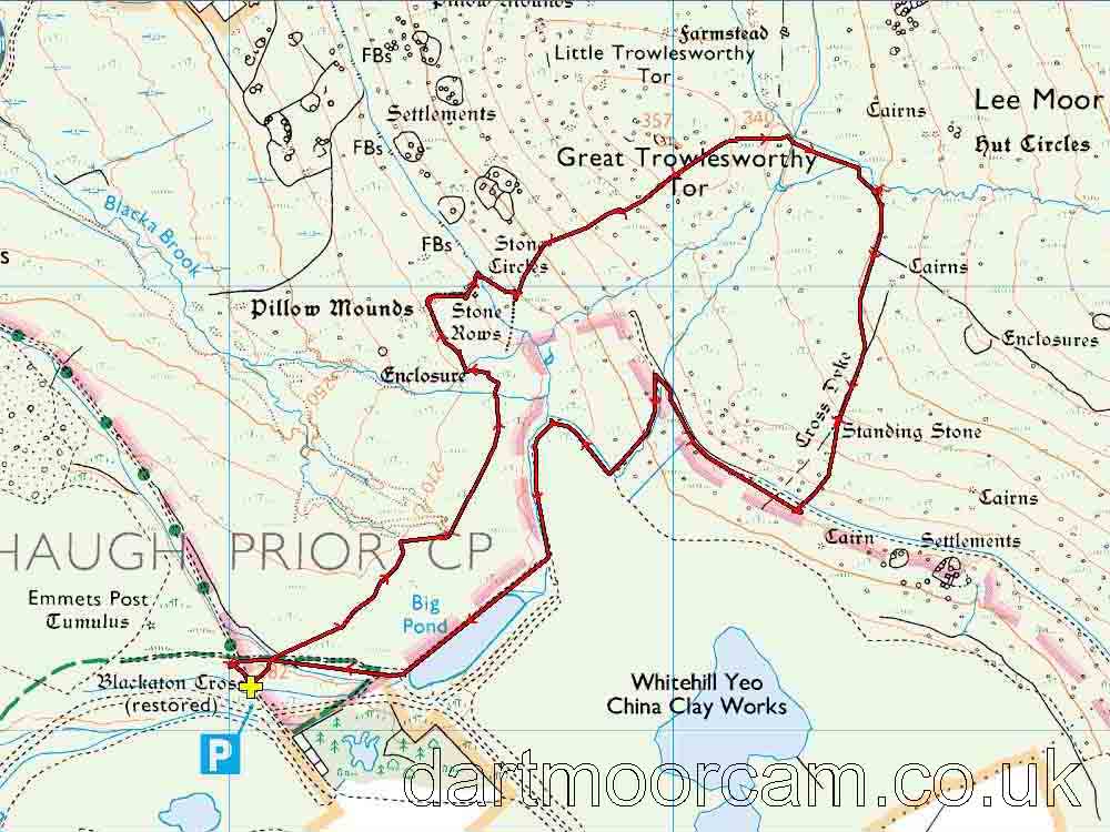
MAP: Red = GPS satellite track of the walk.

Ordnance Survey © Crown copyright 2005. All rights reserved. Licence number
100047373.
Also, Copyright © 2005, Memory-Map Europe, with permission.
This walk was accessed from the turn-off at Cadover Bridge (SX 5555 6461), reaching the car park (marked by the yellow cross and the P symbol on the map) along the track marked by the green dots.
Statistics
Distance - 5.94 km / 3.7 miles
All photographs on this web site are copyright ©2007-2016 Keith Ryan.