

This walk: 2008-7-18. Whiteworks, cist, tin mine remains. This was a black-sky day with heavy rain in the middle of July ..... the planned route around Foxtor Mires was abandoned before we started. During a lull, we had a short walk to find a solitary cist not far from the road. We then walked to the end of the road (that runs south from Princetown to Whiteworks). A very short outing - not a good day for getting cameras wet!
Walk details below - Information about the route etc.

The cist, at SX 60765 70480 � 5 m (GPS 'fix'). This is a cist within a cairn/retaining circle. This is just 15 paces from the leat.

A view into the cist.

Looking from the cist towards Whiteworks.

Looking across Foxtor Mires.

Looking northerly along the leat by the cist.

Looking towards the south, where the leat runs towards Nun's Cross

Tin workings at Whiteworks, the shaft.

A gatepost and wall feature.

Looking west at the tin mine ruins.

Similar to the prevous photo but slightly more to the north.

Close-up of the tree (unidentified).

Ditto, second tree.
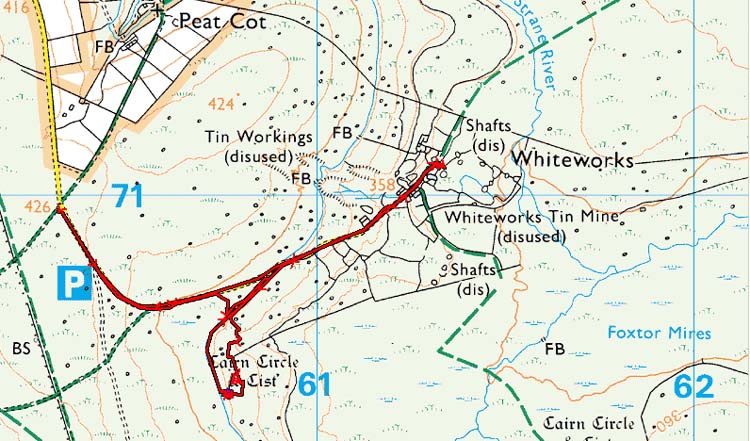
MAP: Red = GPS satellite track of the actual walk.

Reproduced from Dartmoor OS Explorer map 1:25 000 scale by
permission of Ordnance Survey
on behalf of The Controller of Her Majesty's
Stationery Office.
© Crown copyright. All rights reserved. Licence number 100047373.
Also, Copyright © 2005, Memory-Map Europe, with permission
The roads to Princetown were easy, main roads but the road from Princetown to Whiteworks is single track. We helped a large coach to reverse and turn (just!) in our parking spot at Peat Cot, it could not manage the manoeuvre at the P symbol on the map.
Statistics
Distance - 3.8 km / 2.3 miles
Start 11 am, Finish 12.35 pm. Duration 1 hr 35 min
Overall average 2.4 kph / 1.5 mph
All photographs on this web site are copyright ©2007-2016 Keith Ryan.