![]()


This walk: 2008-3-6 This walk is really a short GPS exercise to find stones in the Haytor Down area marked on the map as boundary stones.
The line of stones mark the boundary between Ilsington and Bovey Tracey Civil Parishes at the south-east i.e. Haytor end and at the other end, to the north-west, they separate Ilsington and Manaton parishes.
Some of the stones were seen on a recent map-and-compass walk (2008-2-18 Haytor in the mist) although one intended stone was not seen. They are referred to on page 298, Crossing's Guide to Dartmoor, 1912 edition (reprinted Peninsula Press, 1980, ISBN 1-872640-16-7, �12.95).
The "Prince Albert" and "Prince of Wales" stones were found previously but the one between them, engraved "OWLACO MBE BURROW", was missed. There was a further stone in the series that was located this time (engraved "IJ") and two other boundary stones, engraved "6" and "BB".
This time, the stones' positions on the OS map were put into a GPS unit and found using the "Find - Go to" commands. Once located, their positions were then "fixed" by GPS, to within � 4 or 5 meters. They were mostly within a few yards of their map references although gorse makes them a little difficult to find without the GPS unit.
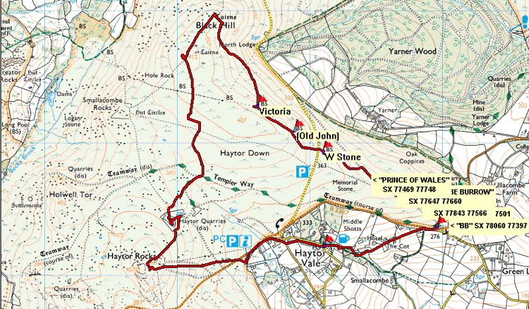
The area is shown in the overview and detail maps following .....
Walk details below - Information about the route etc.
See the map below for the detail of this excursion ......

Reproduced from Dartmoor OS Explorer map 1:25 000 scale by
permission of Ordnance Survey
on behalf of The Controller of Her Majesty's
Stationery Office.
© Crown copyright. All rights reserved. Licence number 100047373.
Also, Copyright © 2005, Memory-Map Europe, with permission
Above: Red = part of the GPS track of the walk on 18 February 2008.

The first stone, a couple of meters from the road, at SX 78059 77385 � 5 meters. It is engraved either "6", as a number, or "b" as an italicised letter.

The next, near-neighbouring, stone at SX 78060 77397 � 4 meters, engraved "BB". This is about 12 meters from the previous stone.

This stone, the next in the series, is at SX 77943 77501 � 4 meters. The stone is engraved "IJ", the letters being above one another at the extreme left end. It looks as though perhaps these were the first letters of words that were never finished? More detail in the next photo .....

Detail from the previous photo.

"DS 1853" on the next stone, one of the series on Haytor Down erected by the Duke of Somerset in 1853 to mark the boundary of his land (which coincides with the parish boundaries mentioned above). This one is at SX 77843 77566 � 4 meters. Yarner Wood is in the background.
See next photo for the reverse view .....

Reverse face of the stone in the previous photo, at SX 77843 77566 � 4 meters, engraved:
| OWLACO MBE BURROW |
This is referred to by Crossing as "Owlacombe Barrow", although as he says, there is no tumulus to be seen in the area today.
This excursion was simply a GPS excise using the "Go to" commands against the stored Ordnance Survey National Grid references for the stones, walking as far as the "Prince of Wales" stone indicated on the maps above.
Parking P and access are as described for the previous walk in the area although we parked on the small roadside layby near the first stone, where thew red GPS track crossed the road (bottom left corner of the second map above, at SX 77920 77341.
Statistics - None recorded as the walk was
little more than a short perambulation.
All photographs on this web site are copyright ©2007-2016 Keith Ryan.