

NB - This web page was only the fifth page undertaken after purchasing a small digital camera. The photos in 2007 were processed for the standard 800 x 600 pixel displays in use at that time - the maximum file size here is 116 KB. The page was titivated regarding the photo levels etc. on 17th April 2017 but the images are the same size. In 2017, the images are processed for 1600 x 900 screens, although they are now displayed at 1200 pixels across the screen. They are best viewed after pressing the F11 key, for Full Screen View, press it again to return to Normal View.

View of Gutter Tor (SX 57785 66870) from near the start of the walk, beside the trees around the Scout Hut

View of Sheeps Tor (at SX 56535 6824) from the same viewpoint as above

Another view of Gutter Tor from near the Scout Hut

Stone Row at SX 59060 66860 running to a large standing stone at the far end with a single stone off to the left and a large cairn to the right

Another view of the row and cairn

The stone at the far end with two walkers to show its relative height. Note the second stone row can be seen in the background

The cairn and large end stone seen looking back from the River Plym - an opportunity for wet feed, avoided on this crossing - but not the second crossing later!

Shavercombe Falls (SX 59505 66040), difficult to capture well on camera because of the tree falling across and the shade in the gully

Approaching Hen Tor. NB - this tor is surrounded by a large area of rocks

On the left is Gutter Tor, then Sheep's Tor, the top of Peekhill plantation, the rounded shape of Peek Hill with the trees at the scout hut in front, then Sharpitor with Leather Tor in front, then the Stanlake and Raddick plantations. My thanks to GW who supplied the description by email, 13 May 2009.

Hen Tor, as close as I got, at SX 59338 65300

Hen Tor seen from the route to Legis Tor

Possibly Down Tor, Sharpitor and Leather Tor (right) from the same spot at the previous photo. Trees in the forestry area around the north end of Burrator reservoir can be seen at the right

Approaching Legis Tor, complete with a fence around enclosed land. The has to be crossed using stiles

Okay - a stile! At SX 57337 65850

En route from Legis Tor to Gutter Tor, looking back at Hen Tor, which is surrounded by bracken (darker brown this time of year) and rocks i.e. hard "going"

Sign on another gate on the bridle path (SX 57646 66455)

Close to previous photo

Gutter Tor (SX 57785 66870) - a nice area of short grass, unlike Hen Tor!

Another view of Sheeps Tor, Leather Tor and Sharpitor as seen from among the rocks of Gutter Tor

Rock detail at Gutter Tor

More rock detail at Gutter Tor, looking south-east with Hen Tor in the distance

Cist, a stone burial box for cremated ashes from the Neolithic period. The surrounding circular cairn is not easy to distinguish
Another GPS walk, using "know-how" gained from
All map references above are from a product for Dartmoor & Exmoor
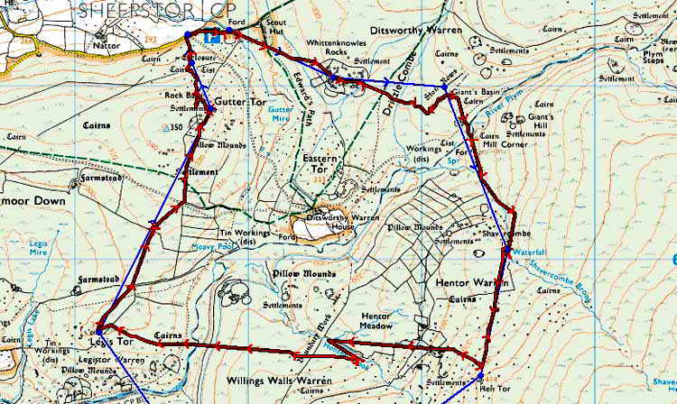
The walk was planned for 8.2 km / 5.1 miles but it was cut short when I decided my legs were older than I thought! Its a wise man and all that ...... At the end of the walk, the Track facility on the GPS unit had recorded 8.73 km / 5.42 miles - that is probably accounted for by all the detours for photos positions and the two river and 1 leat crossings and going around bracken/clitter, the tussocks and detours among some of the ground etc. Amazing how it adds up compared to the crow's straight flight line!

Reproduced from Dartmoor OS Explorer map 1:25 000 scale by
permission of Ordnance Survey
on behalf of The Controller of Her Majesty's
Stationery Office.
© Crown copyright. All rights reserved. Licence number WL 10021.
Also, Copyright © 2005, Memory-Map Europe, with permission
Access was via Burrator dam and Sheepstor village, with parking at the P symbol at the top of the map. The BLUE track was the planned route and the RED track is the actual route walked. I would recommend going past the Scout Hut rather cutting straight across from the car because the ground is boggy.
CAUTION - there were problems with the route - crossing the Plym at SX 59320 66678 was not too difficult although you get your boots wet (wear gaiter). Crossing it again at SX 57710 65478 is a different matter, you get your FEET wet, almost up to the knees, gaiters don't stop this depth and width reaching you! Poor planning! You also encounter a fast-flowing leat at SX 57810 65468, this is where I threw the rucksac across into soft bracken and the camera-&-tripod too. Then, a running jump off a large rock ..... Not bad for a pensioner in training for the Iron Man Competition .....
All photographs on this web site are copyright ©2007-2016 Keith Ryan.
All rights reserved - please email for permissions